A mild winter is about to end in spectacular fashion as a cold front straight from the Arctic passes over the Outer Banks. The Outer Banks Voice has the story.
Wind, possible thunderstorms ushering in Arctic cold front
Get ready for a deep freeze.
A strong Arctic cold front will push through eastern North Carolina beginning early Sunday morning, bringing strong winds, possible thunderstorms and plummeting temperatures.
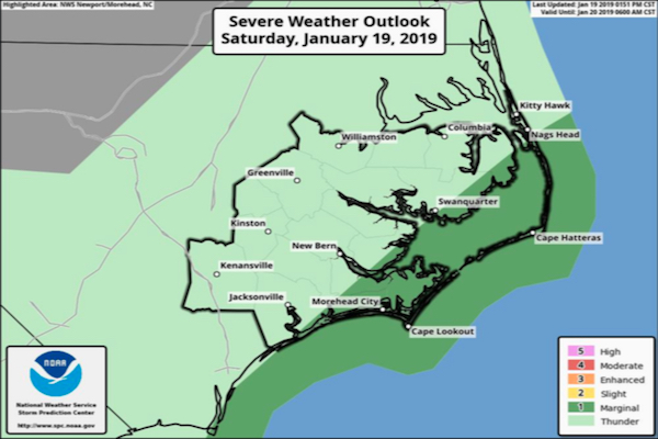
Isolated strong to severe thunderstorms, and the potential for tornadoes, will be possible along the coast from 4-9 a.m. Sunday, the National Weather Service Newport/Morehead City office says.
Gusty southwest winds are expected to develop overnight and may cause some inundation along low-lying areas near the Croatan and Roanoke sounds from Manteo to Ocracoke, the National Weather Service Newport/Morehead City office reports.
Strong northwest winds, gusting 35 to 45 mph, will move in later in the day Sunday, and temperatures will nosedive.
Temperatures in the 20s, with wind chills between 5 and 15 degrees, are expected Monday morning, the weather service said.
Local officials are advising residents to take precautions against frozen water lines by turning off outdoor faucets, opening kitchen and bathroom cabinet doors to let warm air flow in, and considering letting cold water drip from faucets to prevent freezing.