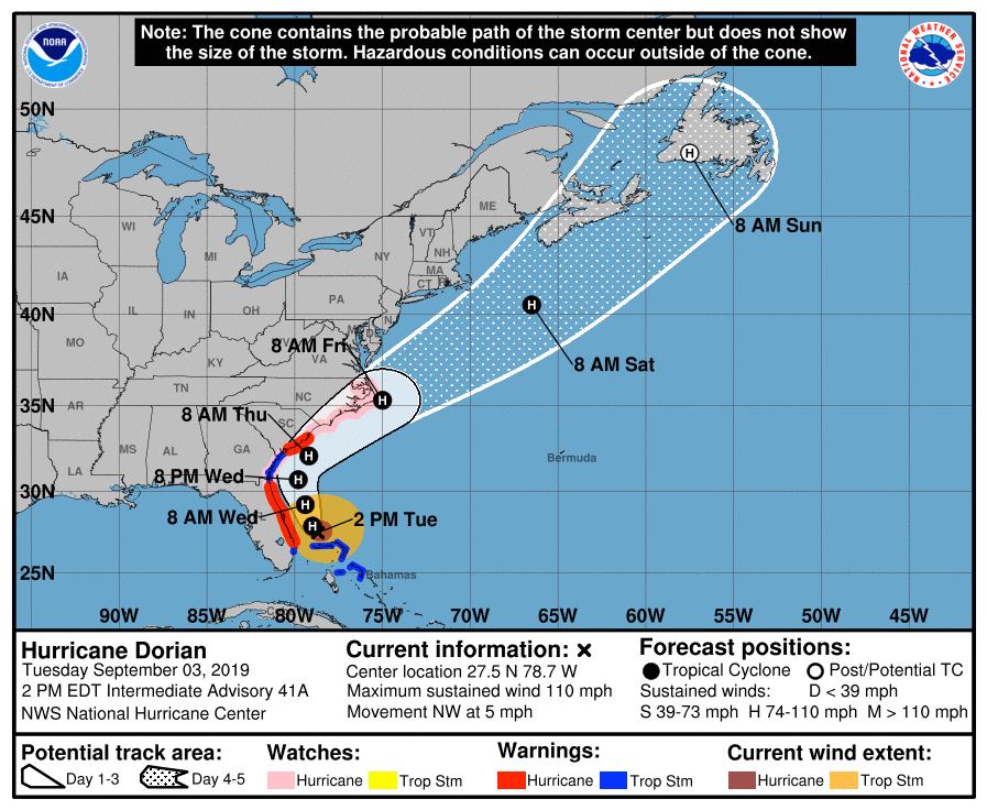
Storm Track Appears to Pass Close to Cape Hatteras
With so much coverage of Hurricane Dorian trying to sort through all the information can get pretty confusing. What we thought we would do at Hidden Outer Banks was take some of the information that is readily available on the National Hurricane Center (NHC) website, see if we can make some sense out of it and write about what that means for the Outer Banks.
It is important to note that as we write this on Tuesday early afternoon, all visitors have been ordered to evacuate, and there is a mandatory evacuation for Dare County residents beginning tomorrow. It’s unclear how many residents will abide by that.
We could take up a lot of time just discussing why the evacuation was ordered and why so many residents may choose to stay. Rather than do that, however, we’re going to take a look at the information that is available, information that does play into the decisions people make.
Please keep in mind that when looking at the maps, the effects from Dorian will be felt beginning Thursday afternoon into Friday moving south to north.
Hurricane Wind Probability
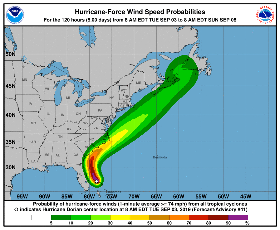
This is a NHC map showing the probability of hurricane force winds over the next five days from Tuesday morning. Looking carefully, the probability of winds 74 mph or greater striking the Outer Banks vary between 20 to 40 per cent.
That being said, though, Cape Hatteras is very close to the 40-50% range, and the current prediction for Buxton reflects that with a brief period of winds between 75-80 mph.
North of Oregon Inlet those probabilities drop to 20-30% and even lower on the Currituck Banks.
Tropical Storm Wind Probability
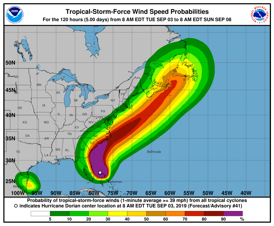
If Dorian continues on its current track, this is where the wind impacts of Dorian show up.
Looking at this map, it is clear that the entire Outer Banks will experience tropical storm force winds. That is reflected in the local forecasts with Kitty Hawk’s winds briefly topping out between 55-60 mph. Twenty-five miles north in Corolla, those winds diminish to 45-50 mph.
Rainfall Probability
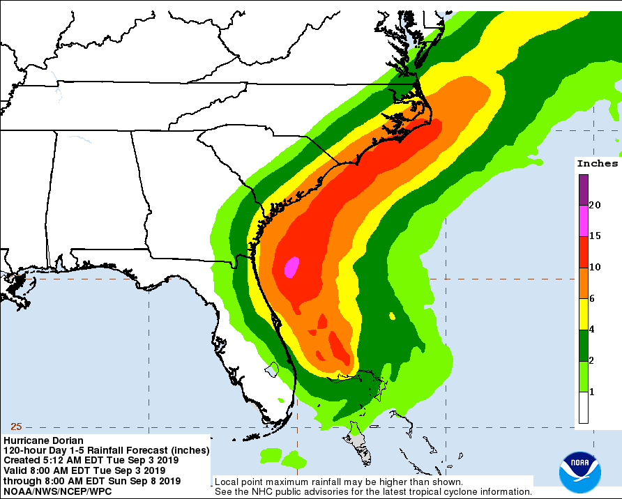
Here is what may be the biggest problem the Outer Banks will face. Although strong tropical force winds can create problems, 6″-10″ of rain in a 24 hour period carries with it a very real possibility of flooding.
The flooding will be standing water, and there are a number of areas roads we already know will be under water by Friday morning.
From the map, it looks as though Hatteras Island will be getting somewhere in excess of 10″ of rain.
Hopefully this information helps in understanding what is happening with Hurricane Dorian and the Outer Banks. A Hurricane Watch was issued a little while ago for Ocracoke and all of coastal Dare County. If the predictive models hold true, the watch is more of a cautionary step for the Outer Banks north of Oregon Inlet rather than a specific threat.
Content written by Kip Tabb.