No OBX local could forget that Hurricane Irene rolled over the Outer Banks in August of 2011.
TD8 probably wouldn’t have any significance attached to it under most circumstances… a minimal tropical system just off the OBX that’s not even going to make landfall—but this is the fifth anniversary of Hurricane Irene, a storm many of us would rather forget.
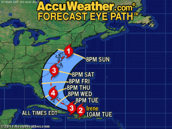
Irene was not the most powerful hurricane to ever strike the Outer Banks; it did not have the highest winds or most rain. What it did have though was the most troublesome tracking, with the eye pushing right up Pamlico Sound and exiting over Pea Island.
Video footage of Irene’s aftermath, courtesy of Oregon Inlet Idiots YouTube channel.
The first winds of a hurricane are from the north and northeast and Irene’s winds pushed the waters of the Outer Banks sounds to the mainland. As the winds shifted to the south and west, they pushed a wall of water north.
Downtown Manteo was under three to four feet of water, whole sections of homes in the TriVillage area were flooded, property as far north as Kitty Hawk was under water and in two separate places on Pea Island new inlets formed.
Waves pushing in from the sea do not form inlets; an inlet is actually an outlet, created when the force of waves in a bay or sound slices through the land separating it from the sea.
Just north of Rodanthe, at the S Curves, a broad shallow inlet formed. The inlet in Pea Island National Wildlife Refuge, though was deep and about 125 yards across.
Forming just north of what was once called New Inlet, the breach had to be bridged and NCDOT brought in a temporary “Mauby” bridge to keep traffic moving.
The S Curve breach was filled in fairly quickly, a new dune line constructed with massive sandbags as a base.
Irene was a destructive force, yet by December of 2011 NCDOT had reconnected Hatteras Island with the northern Outer Banks and most of the storm damage had been repaired.
Kip Tabb, HOBX Correspondent