A hurricane off the Outer Banks on the 4th of July? That’s a new experience for all of us.
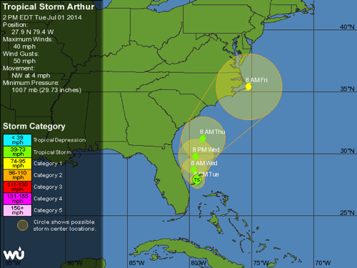
Of course we don’t know exactly where Tropical Storm Arthur is going to go, but the storm track everyone is looking at right now has it at hurricane strength and brushing Cape Hatteras Friday morning as it turns out to sea.
If that is the case, and almost all of the models paint a similar picture, the northern Outer Banks—everything north of Oregon Inlet—will have a very wet and very windy day, but nothing significantly worse than one of our nor’easters. And, unlike nor’easters that often linger for days, Arthur will be moving quickly and should be gone by the evening.
A number of the things seem to get overlooked when news teams descend on the Outer Banks to report on an approaching hurricane. From Carova to Ocracoke it’s a little over 120 miles and there is a very noticeable bend in the shoreline. A hurricane that parallels the coast between Ocracoke and Hatteras will be moving away from the shoreline for all towns north of Cape Hatteras–where the bend occurs.
What that means is Buxton and Ocracoke may be looking at a day with 50 or 60mph winds; Kill Devil Hills and Kitty Hawk–25 or 30 mph winds.
Although storm tracking has gotten much better over the past 10 years, there is still a little bit of “best guess based on available knowledge”. A 20 mile wiggle either to the east or west, changes the the forecast considerably for coastal towns. Twenty miles to the east and Kitty Hawk will probably have a day of squalls and sunshine. Twenty miles west and the town will have a lot more rain and wind.
A quick note about July 4th celebrations: if Hurricane Arthur maintains its current track, look for fireworks to be pushed back a least by a day. Avon has already rescheduled their plans for Monday.
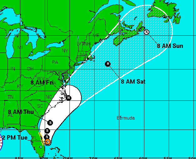
Of course, storm tracks can change quickly, so please monitor local news and information sites. The National Hurricane Center at NOAA posts regular updates.
[box type=”bio”] Dare County Emergency Management, as always, is keeping a close eye on this developing situation. Read their most recent announcement and sign up for email updates HERE.[/box]